
Lulworth Cove: The Geological Horseshoe and the Gateway to the Purbeck Coast
The Perfect Circle: A Landscape of Hidden Waters and White Cliffs
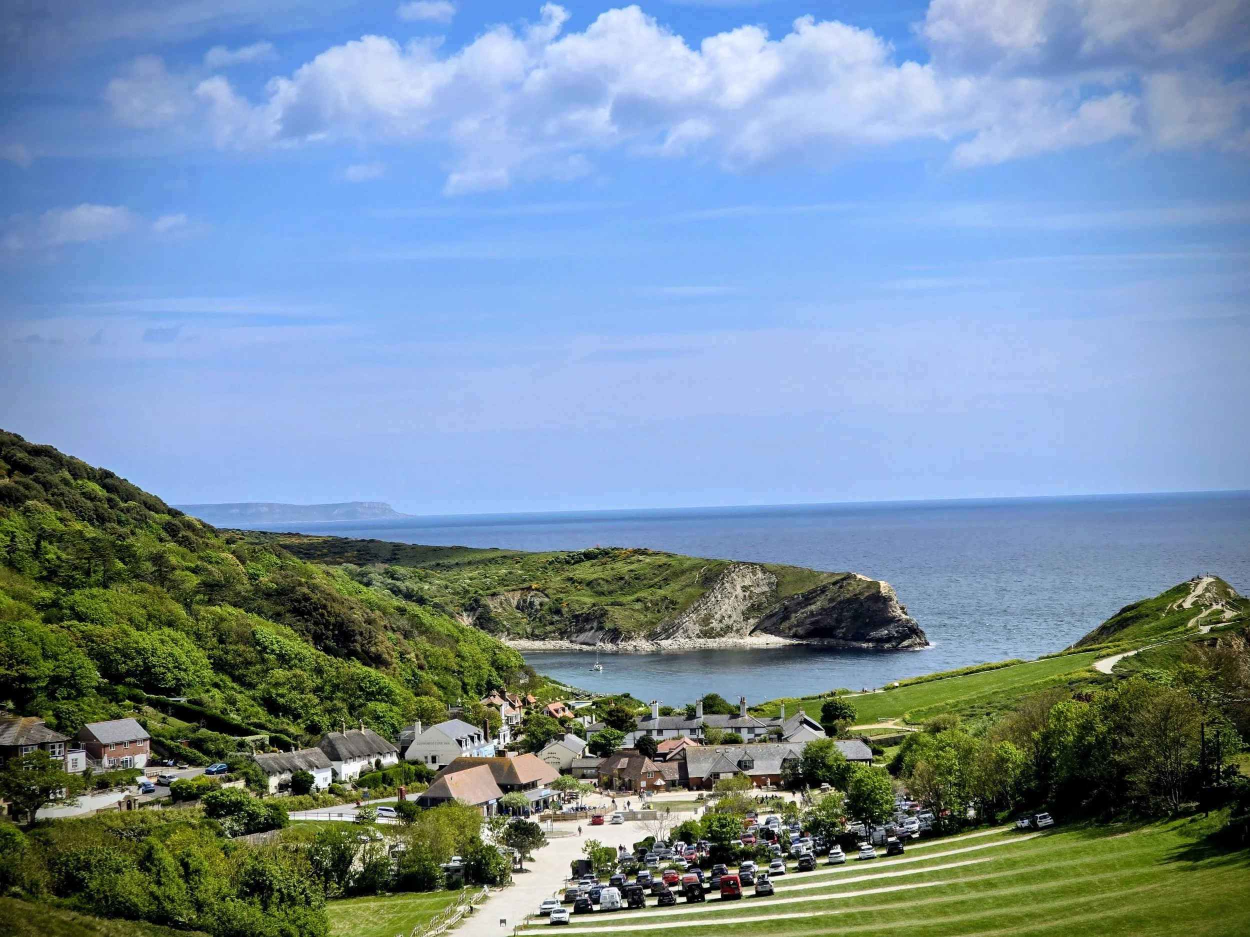
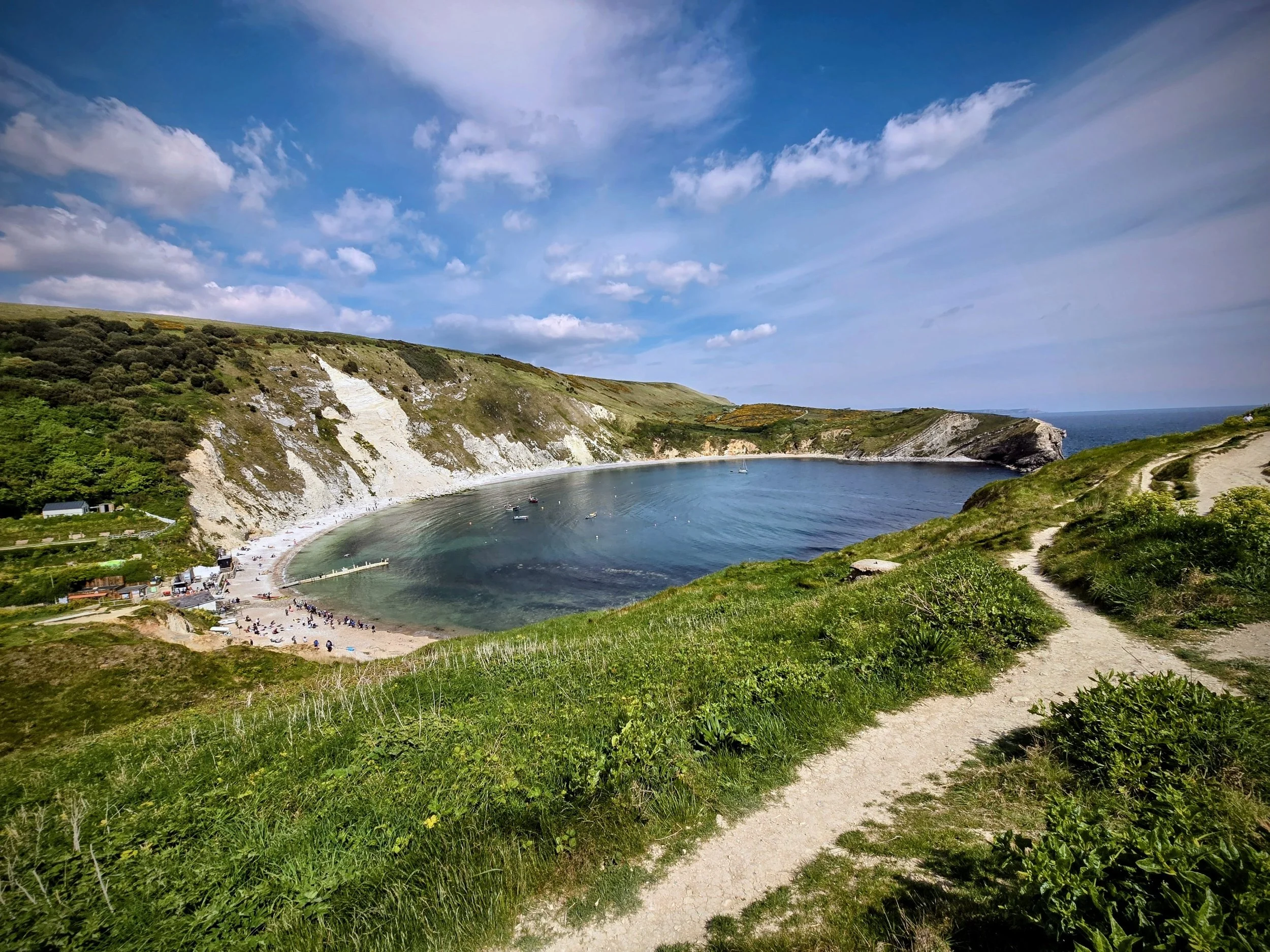
Nestled on the edge of the Lulworth Estate in Dorset, Lulworth Cove is perhaps the most geometrically perfect natural harbor in the British Isles. From the air, it appears as a near-perfect turquoise horseshoe, carved into the high white chalk of the Jurassic Coast UNESCO World Heritage site. In 2026, it remains a site of global geological significance and a sanctuary for those seeking the quintessential English coastal experience.
For the Explorers Insight reader, Lulworth Cove is a tactical study in the power of the sea. While the waters inside the cove are often as still as a lake, they are the result of a million-year battle between the Atlantic Ocean and the vertical layers of the earth.
🧭 The Geology of the Cove: A 150-Million-Year Blueprint
Lulworth Cove is more than just a beautiful beach; it is a "textbook" example of coastal erosion. To understand its shape, one must look at the specific arrangement of rock layers that run parallel to the shoreline.
The Protective Armor: Portland Limestone
The "entrance" to the cove is guarded by two massive bastions of Portland Limestone. This rock is exceptionally hard and resistant to the waves. For millennia, this limestone wall stood as a solid barrier, protecting the softer land behind it.
The Breach and the Basin
Approximately 10,000 years ago, at the end of the last Ice Age, the sea finally found a weak spot—likely a river valley or a fault line—in the limestone armor. Once the water punched through, it reached the Purbeck Beds and Wealden Clays.
The Rapid Erosion: Unlike the limestone, these clays are soft and crumble easily. The sea was able to "hollow out" the land behind the limestone wall much faster than it could widen the entrance.
The Chalk Boundary: The erosion eventually hit the massive wall of Cretaceous Chalk that forms the high cliffs at the back of the cove. Because chalk is harder than clay but softer than limestone, it slowed the sea's progress, creating the circular basin we see today.
The Lulworth Crumple
Just to the west of the cove entrance lies the Stair Hole. Here, you can see the "Lulworth Crumple"—a spectacular series of folds in the rock where the tectonic pressure of the Alpine Orogeny literally buckled the stone like a piece of carpet. It is one of the most famous geological sites in Europe.
🧭 The Deep History: From Smugglers to Scientists
The human history of Lulworth is as colorful as the layers of its cliffs.
The Smuggling Legacy: In the 18th and 19th centuries, Lulworth’s secluded nature made it a haven for "the trade." Contraband brandy, lace, and tobacco from France were regularly landed in the cove and spirited up the "Smugglers' Path" to the safety of the inland villages.
The Arrival of the Poets: By the Victorian era, Lulworth had become a destination for the creative elite. John Keats spent some of his final days in England on the shores of the cove, and the landscape famously inspired the writings of Thomas Hardy, who renamed the area "Lulstead" in his Wessex novels.
The World War II Defense: During the 1940s, Lulworth was a vital part of the coastal defense system. The surrounding hills, known as the Lulworth Ranges, are still used by the British Army today for tank training, preserving a massive expanse of the landscape from modern development.
🧭 Landmarks and Significance
While the cove itself is the primary draw, the immediate area is filled with secondary landmarks that complete the Lulworth experience.
1. Stair Hole
Located just a 5-minute walk west of the main cove, Stair Hole is "Lulworth Cove in the making." It features several arches where the sea is currently punching through the limestone.
The Insight: It provides a "before and after" look at how the main cove was formed.
2. The Fossil Forest
Located on the eastern ledge of the cove (accessible when the Army Ranges are open), this is the most complete fossilized remains of a Jurassic forest in the world.
The Highlight: You can see the "algal burrs"—stone rings that formed around the bases of ancient cycad trees 144 million years ago.
3. Bindon Hill
The massive ridge that looms over the north side of the cove. It is topped by an Iron Age hillfort, proving that the strategic value of this harbor was recognized by our ancestors over 2,000 years ago.
🧭 Best Places to Eat in Lulworth (2026)
Lulworth has evolved from a sleepy fishing village into a culinary hub that focuses on fresh Dorset produce.
Near the coast, several local spots offer great food depending on what you’re in the mood for. The Lulworth Cove Inn is known for its fresh-caught lobster and crab and is perfect if you want a traditional pub atmosphere with a scenic view. Finley’s Café is a great place to stop for a Dorset cream tea, especially if you want a quiet break after the walk from Durdle Door. For something more casual, The Boat Shed serves grilled seafood platters and offers relaxed dining right by the edge of the shingle beach. If you’re planning to explore the cliff paths, Lulworth Deli is a good choice for artisanal sandwiches that make an excellent high-quality picnic to take with you.
🧭 How to Get There: Tactical Travel Tips
By Car
Lulworth is located off the A352. Follow signs for Wool and then the brown tourist signs for Lulworth Cove.
Parking: The main Lulworth Estate car park is large but fills up by 10:30 AM in the summer. It uses a "Pay on Exit" or "Pre-pay" system that also covers Durdle Door.
By Train and Bus (The Eco-Friendly Choice)
The nearest train station is Wool (on the London Waterloo to Weymouth line).
The Bus Link: From Wool Station, catch the X54 or X50 Jurassic Coaster. In 2026, these buses run frequently and drop you right at the Lulworth Heritage Centre.
🧭 Specialized Tips for the 2026 Explorer
The "Range" Calendar: The eastern side of the cove (including the Fossil Forest and Mupe Bay) is part of the Ministry of Defence Lulworth Ranges. It is only open on weekends and during major school holidays. Check the "Lulworth Range Firing Times" online before you plan an eastern hike.
The Low Tide Secret: At very low tide, you can walk around the western "toe" of the cove to explore hidden rock pools that are teeming with Victorian-era biodiversity—anemones, velvet swimming crabs, and rare seaweeds.
Photography: For the iconic "horseshoe" shot, don't stay at sea level. Climb the path toward Durdle Door (to the west) or Bindon Hill (to the east). The higher you go, the more the perfect circle of the cove reveals itself.
-
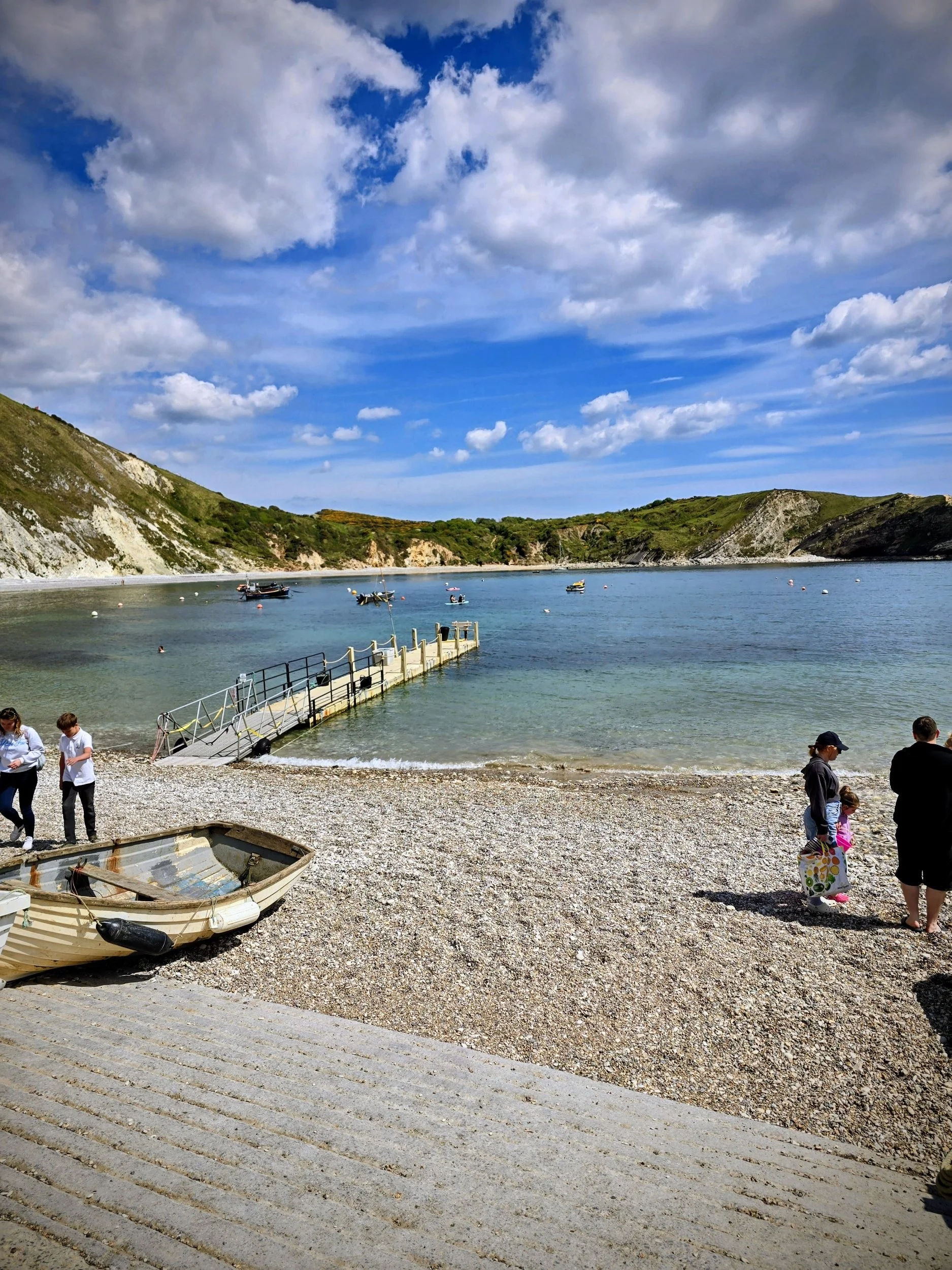
The beach is primarily composed of white shingle and pebbles. While beautiful, it is recommended to bring thick beach mats or chairs if you plan to sunbathe.
-
Yes. Because the entrance is so narrow, the waters are remarkably calm and sheltered from the Atlantic swells, making it one of the safest places for open-water swimming on the South Coast.
-
The path from the car park to the mouth of the cove is paved and relatively flat, making it accessible for strollers and wheelchairs. However, the beach itself is deep pebble and difficult to navigate with wheels.